High in the central highlands of Socotra, the landscape of Diksam Plateau can look deceptively calm at first. Wide limestone ground stretches outward, the plateau feels open and exposed, and then suddenly the land gives way. The surface breaks apart at the edge of a massive drop where the highlands collapse into one of the island’s most dramatic interior landforms.
That sudden rupture is Dirhur Canyon.
From the plateau rim, the ground falls sharply into a deep gorge carved through Socotra’s interior terrain. Cliffs plunge downward, rocky slopes spill into the valley, and the scale of the landscape expands fast enough to make the plateau behind you feel strangely small. What looked like a simple upland route a few minutes earlier turns into a canyon panorama of limestone walls, broken ridges and empty space.
Dirhur stands out because it changes the rhythm of the highlands. Around Diksam Plateau, the scenery is often defined by open limestone surfaces, wind, scattered vegetation and those surreal dragon blood tree landscapes further on near Firmihin Forest. At the canyon edge, though, everything turns vertical. The land stops behaving like a plateau and starts behaving like a fracture.
That contrast is what makes the place memorable. It is not only scenic. It feels abrupt, raw, almost violent in geological terms, even if the view itself is quiet.
Because of its location between major central highlands stops, Dirhur Canyon is usually visited as part of a broader inland route across Socotra. Travelers heading through Diksam and onward toward Firmihin often stop at the canyon rim to take in the scale of the island’s interior mountains and valleys.
Dirhur Canyon at a Glance
A deep limestone canyon cutting through the central highlands of Socotra near Diksam Plateau and Firmihin Forest.
Central highlands of Socotra
Deep limestone canyon
30–60 minutes
Panoramic canyon viewpoints
The Geological Formation of Dirhur Canyon
Dirhur Canyon was shaped over long geological periods as erosion gradually cut through the limestone plateau. Socotra is dry now for much of the year, but the island’s interior terrain carries the marks of older water flow, seasonal runoff and repeated erosion acting on the rock over a very long time.
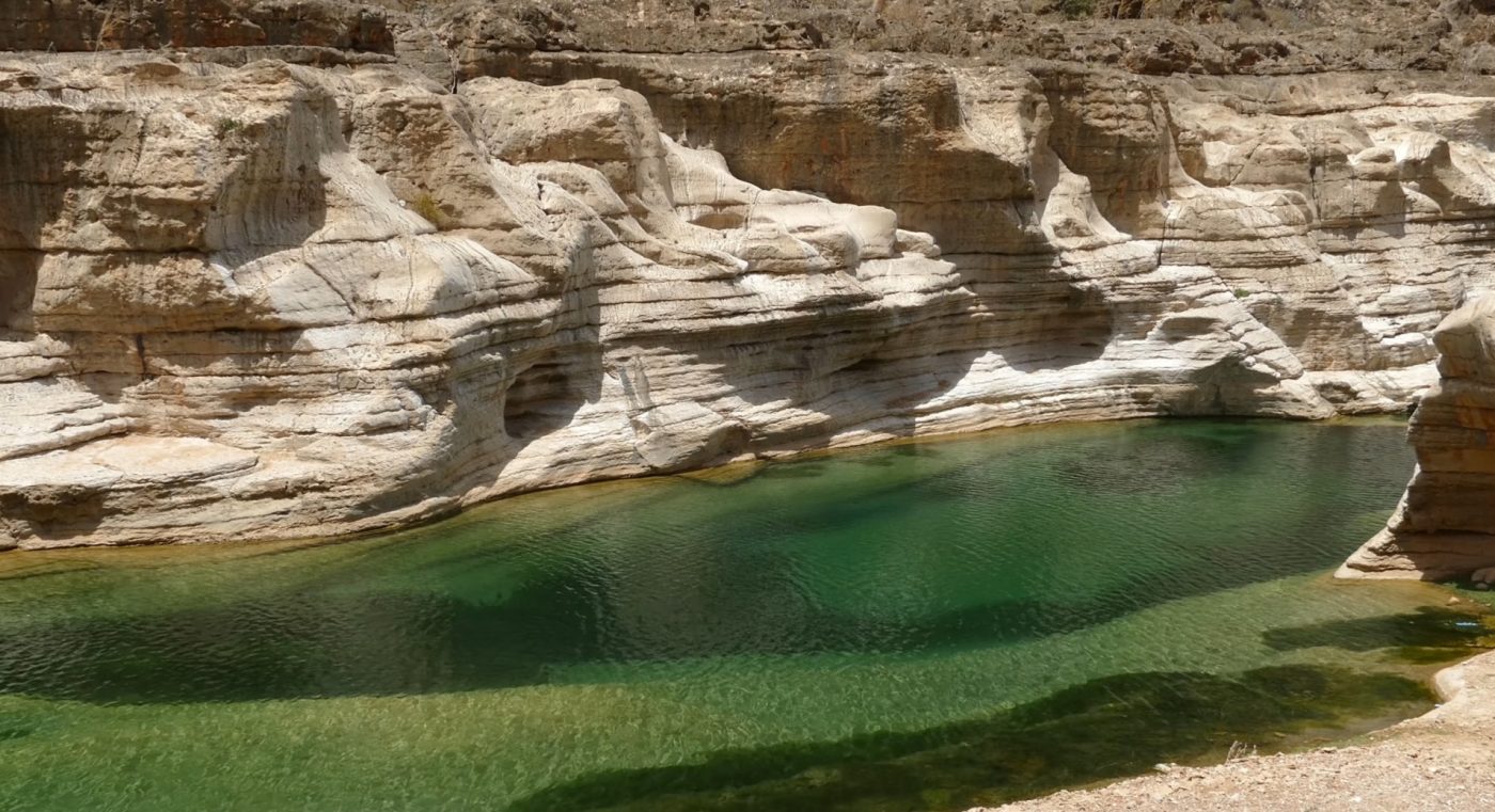
That process carved channels, valleys and steep-sided breaks across the central highlands. Dirhur is one of the clearest examples of this pattern. The canyon exposes layers of limestone that would stay hidden if the plateau had remained intact, and those exposed walls give the whole landscape a stripped-open feel, as if the island’s structure has been pulled into view.
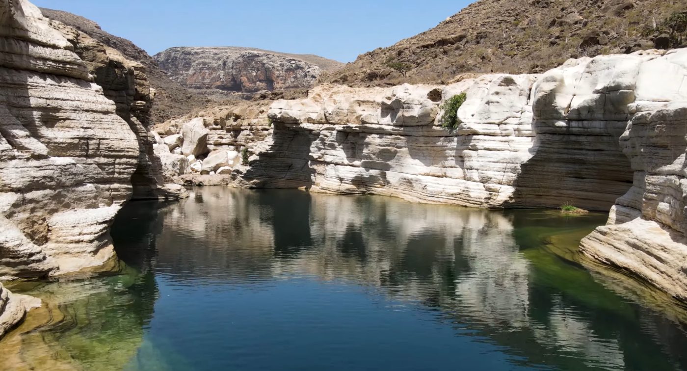
From the rim you can see how sharply the change happens. The flat or gently rolling surface of the plateau suddenly gives way to steep slopes, fractured ledges and deep interior terrain dropping toward the valley floor. In some conditions, especially when haze, low cloud or drifting mist move through the gorge, the depth becomes even harder to judge. It looks farther, steeper, more dramatic than expected.
And that’s the thing with Dirhur. From a distance it can seem like just another valley. Stand near the edge and it stops looking ordinary very fast.
The rock walls, the broken escarpments, the sheer depth of the cut — it all makes the canyon feel larger than the map version of it in your head. Bigger, harsher, more exposed.
Views from the Canyon Rim
Most people experience Dirhur Canyon from viewpoints along the rim rather than descending into the gorge itself. That is where the canyon really works anyway. The edge gives you the full reveal — the plateau behind, the sudden drop ahead, the layers of ridges and interior valleys stretching beyond.
Standing near the rim, you can watch the landscape reorganize itself in front of you. The open limestone highland ends. The cliffs plunge downward. Beyond them, the terrain keeps folding into more ridges, more slopes, more cuts in the rock. Nothing feels neat or symmetrical. It’s all broken lines and depth.
On clear days the views run for a long distance across Socotra’s interior mountain country. The contrast is part of the spectacle: one moment you are driving through a relatively open plateau environment, and the next you are staring into a canyon system that seems to tear the highlands apart.
Light matters here more than people think. Midday can flatten the rock a bit, bleaching some of the texture. Earlier or later in the day the canyon walls gain more relief, shadows deepen, and the shape of the gorge becomes easier to read. The ridges separate visually. The escarpments look sharper. The whole place feels more severe.
Honestly, even a short stop works here because the view hits quickly. But if the conditions are good, it’s worth staying a little longer than the standard rushed roadside pause. The canyon has layers, and your eye needs a minute to catch up.
Why Dirhur Canyon Feels Important in the Highlands
Socotra’s central highlands are already strange in the best way — elevated limestone country, dragon blood tree groves, dry plateau winds, scattered endemic vegetation, huge internal variation in terrain. Dirhur Canyon adds another dimension to that whole zone.
It shows that the highlands are not just broad uplands with trees and viewpoints. They are structurally dramatic. Fractured. Deeply cut. The canyon turns the mountains into something more physical, more muscular.
That matters in a travel route because it keeps the inland part of Socotra from blending into one long plateau drive. Diksam gives you highland atmosphere. Firmihin gives you the iconic dragon blood tree ecosystem. Dirhur gives you rupture and scale.
Maybe that sounds grand. Still true.
It is one of those stops that helps the island make sense topographically. You see the plateau, then the break, then the drop into the interior. Suddenly the geography is not abstract anymore.
How Dirhur Canyon Fits Into the Highlands Route
Dirhur Canyon is rarely treated as a standalone destination. It usually appears as one part of the central highlands route linking Diksam Plateau, canyon viewpoints and the dragon blood tree landscapes of Firmihin Forest.
That sequence works well because each stop shows a different side of the same upland region. First the open limestone plateau. Then the canyon edge. Then the forested highland landscape shaped by dragon blood trees. Same broad region, completely different mood.
Most itineraries include a relatively short stop at Dirhur, enough time to walk to a viewpoint, look across the gorge, take photographs and feel that sudden drop in terrain for yourself. Access is easier here than in more remote mountain sections of Socotra, since the canyon viewpoints sit close to the road network crossing the plateau.
So even though the canyon feels wild and severe, it usually fits into the route without much difficulty. That mix of accessibility and raw scenery is a big part of the appeal.
Typical Central Highlands Route
Diksam Plateau
Travelers cross the elevated limestone landscapes of Diksam Plateau, where the highlands open into broad views and scattered dragon blood tree terrain.
Dirhur Canyon
The route pauses at Dirhur Canyon, where visitors stop along the rim to take in the dramatic drop from plateau surface to deep interior gorge.
Firmihin Forest
From the canyon area, many itineraries continue toward Firmihin Forest, where large stands of dragon blood trees spread across the central highlands.
Travel Conditions Around Dirhur Canyon
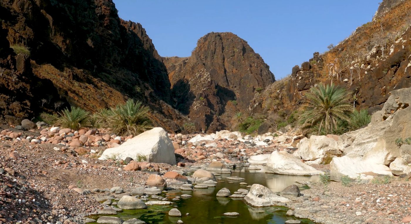
Dirhur Canyon sits out in Socotra’s central highlands, and reaching it usually means crossing Diksam Plateau first. The drive there isn’t exactly smooth. Tracks cut through rocky ground and sometimes hug the edges of slopes that drop away toward the canyon valley. Nothing dramatic if you’re used to mountain roads… still, the terrain keeps your attention.
The road winds slowly across the plateau and the landscape shifts almost without warning. Dragon blood trees start appearing here and there, strange umbrella silhouettes standing against the horizon. Then the ground opens wider, the plateau thins out, and somewhere ahead the canyon edge begins pulling the eye forward.
Near the rim most people leave the vehicle and walk the last few meters toward the viewpoints. The ground here is mostly limestone — uneven, cracked, a little rough underfoot. Nothing extreme, but decent walking shoes help. Especially if you wander along the rim for a better angle over the valley.
What to Expect at Dirhur Canyon
Even with those rough conditions, Dirhur Canyon remains one of the easier places to witness the raw geology of Socotra’s interior. You don’t need a long trek to see it. The plateau road brings you surprisingly close to the edge.
Best Time to Visit Dirhur Canyon
Most visitors reach the canyon during the calmer months between October and April. Weather across Socotra stays milder during this stretch, and the central highlands often feel cooler than the coastal plains below.
Morning tends to offer the clearest views across the canyon valley. The air is usually calmer and the landscape stretches far into the distance without much haze. Some days the light feels sharp enough that every ridge line stands out.
Late afternoon brings a different mood. As the sun lowers, shadows creep slowly across the canyon walls and the rock formations start showing more texture. The valley suddenly looks deeper than it did earlier in the day.
Between June and September seasonal winds sweep across much of Socotra. The plateau feels those winds too. Driving along exposed roads can get dusty, and distant views sometimes blur through haze drifting across the highlands.
How Long to Spend at Dirhur Canyon
Most travelers spend somewhere between thirty minutes and an hour exploring viewpoints along Dirhur Canyon. It’s rarely a long stop. The canyon usually appears as one piece of a larger route through the island’s central mountains.
The visit often comes after crossing Diksam Plateau. Wide limestone terrain, scattered dragon blood trees, open sky… and then suddenly the plateau breaks and the canyon drops away beneath you.
From here many itineraries continue toward Firmihin Forest, where clusters of dragon blood trees spread across the highland plateau. The shift between landscapes happens surprisingly quickly.
Within a short drive the route moves from open plateau to deep canyon views and then into those strange tree forests. Socotra does that a lot — landscapes changing faster than you expect.
Practical Travel Facts
| Location | Central highlands of Socotra Island |
|---|---|
| Landscape type | Deep limestone canyon |
| Typical visit length | 30–60 minutes |
| Nearby destinations | Diksam Plateau, Firmihin Forest |
| Main attraction | Panoramic canyon viewpoints |
| Travel style | Part of the central highlands exploration route |
Final Thoughts on Dirhur Canyon
Dirhur Canyon shows a completely different face of Socotra. One moment you’re driving across a fairly flat limestone plateau, the next the ground drops into a massive canyon carved deep into the island’s interior.
Standing along the rim feels different from the coast. No beaches here, no lagoons. Instead the view stretches across rugged valleys, steep rock walls and quiet mountain terrain.
Together with nearby landscapes like Diksam Plateau and Firmihin Forest, the canyon forms part of the highland heart of Socotra.
For travelers who only expect beaches from the island, Dirhur Canyon usually comes as a surprise. A big one.